File:Asinara map.png
Jump to navigation
Jump to search


Size of this preview: 556 × 600 pixels. Other resolutions: 222 × 240 pixels | 445 × 480 pixels | 700 × 755 pixels.
Original file (700 × 755 pixels, file size: 177 KB, MIME type: image/png)
The revision #12483 of the page named "File:Asinara map.png" does not exist.
This is usually caused by following an outdated history link to a page that has been deleted. Details can be found in the deletion log.
Summary
| Description |
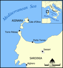
A map of Asinara island off the northwest coast of Sardinia, Italy. Created by NormanEinstein, July 15, 2005. |
| Date | 15 July 2005 (original upload date) |
| Source | No machine-readable source provided. Own work assumed (based on copyright claims). |
| Author | No machine-readable author provided. NormanEinstein assumed (based on copyright claims). |
Licensing
I, the copyright holder of this work, hereby publish it under the following licenses:

|
Permission is granted to copy, distribute and/or modify this document under the terms of the GNU Free Documentation License, Version 1.2 or any later version published by the Free Software Foundation; with no Invariant Sections, no Front-Cover Texts, and no Back-Cover Texts. A copy of the license is included in the section entitled GNU Free Documentation License. |
| This file is licensed under the Creative Commons Attribution-Share Alike 3.0 Unported license. | ||
| ||
| This licensing tag was added to this file as part of the GFDL licensing update. |
You may select the license of your choice.
File history
Click on a date/time to view the file as it appeared at that time.
| Date/Time | Thumbnail | Dimensions | User | Comment | |
|---|---|---|---|---|---|
| current | 15:52, 15 July 2005 | | 700 × 755 (177 KB) | NormanEinstein | A map of Asinara island off the northwest coast of Sardinia, Italy. Created by NormanEinstein, July 15, 2005. {{GFDL-self}} |
File usage
The following page uses this file: